When Drone Photography Makes Sense for Western Slope Properties (and When It Doesn’t)
Drone photography isn’t just for luxury listings. Learn when aerial photos add real value for Western Slope properties—acreage, views, outbuildings—and when ground images are enough.
3D TOURS & VIRTUAL EXPERIENCES
Real estate on Colorado’s Western Slope is uniquely diverse—mountain cabins, sprawling farms, cliffside homes, tight neighborhood lots, and everything in between. Because of that variety, drone photography can be a powerful tool, but it’s not always necessary for every listing.
As an FAA Part 107 Certified Drone Pilot, I’ve worked across Montrose, Delta, Ouray, Ridgway, and the surrounding regions for years. This guide explains when aerial media genuinely adds value—and when traditional ground photography does the job just as well.
What FAA Part 107 Certification Means for You
Before diving into when drone photography is worth it, it’s important to understand that flying a drone for real estate is not the same as flying one recreationally.
Part 107 certification ensures:
Legal authorization to fly for commercial purposes
Knowledge of airspace classifications across the Western Slope
Safe operations around mountains, ridges, wind tunnels, and airports
Required maintenance, pre-flight checks, and operational logs
Compliance with remote ID rules and visibility requirements
Hiring a certified pilot protects you—and your listing—from legal risk and ensures safer, higher-quality aerial media.
When Drone Photography Does Make Sense
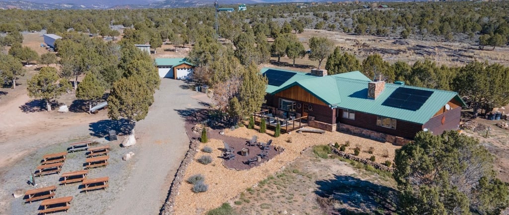
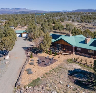
1. Acreage, Farms & Ranches
Acreage is almost impossible to convey from the ground alone. Drone media helps buyers visualize:
property boundaries
irrigation systems
fields, orchards, or grazing areas
shape and topography
natural surroundings
If you’re selling 5+ acres, aerial media is almost always recommended.
2. Mountain, Valley, or Canyon Views
The Western Slope is known for its dramatic scenery. Drones allow you to highlight:
San Juan mountain views
canyon walls and river corridors
mesa edges
valley floors and ridgelines
seasonal beauty (snow, fall colors, spring greens)
Listings with a strong view premium benefit significantly from aerial imagery.
3. Outbuildings & Multi-Structure Properties
Many properties here include:
barns
workshops
guest houses
garages
RV storage
equipment buildings
greenhouses
Drone images show layout, spacing, and access in ways ground photos cannot.
4. Properties With Private Roads or Complex Access
For rural homes—especially in Cimarron, Hotchkiss, or the Uncompahgre Plateau—drones help show:
driveway length and condition
access points
off-grid setups
terrain features such as steep drop-offs or switchbacks
This is critical for buyers moving from out of the area.
5. Homes in Neighborhoods With Community Amenities
In developed areas around Montrose, Ridgway, or Delta, aerial photography helps highlight proximity to:
parks
greenbelts
golf courses
community clubhouses
trails
schools
This gives buyers a clear sense of lifestyle and location.
When Drone Photography Might Not Add Much Value
1. Tight City Lots With Little Context
If the home sits on a small lot with neighbors close on all sides, drone shots might:
make the yard look smaller
showcase roof wear unnecessarily
reveal clutter from adjacent properties
In these cases, ground photography usually creates a more flattering first impression.
2. Lower-Priced Starter Homes
If the listing’s value is based on affordability, not land, location, or views, drone media may not impact buyer activity enough to justify the added cost.
3. Areas With Heavy Tree Coverage
In some forested neighborhoods, even a drone cannot capture much because:
the canopy blocks views
rooflines are hidden
property layout isn’t visible
Ground photography often serves better.
Weather, Wind, and Seasonal Considerations
The Western Slope has unpredictable flight conditions, especially in:
winter snowstorms
spring high winds
canyon wind tunnels
ridgeline turbulence
summer thunderstorms
For safe operations, drones cannot fly during:
strong wind gusts
active precipitation
low visibility
FAA-issued flight restrictions (e.g., fire zones)
A certified pilot understands these limits and works within them.
My Safety & Legal Compliance Standards
Blue Moon Medias follows strict protocols for every flight, including:
pre-flight airspace checks
real-time weather monitoring
secure takeoff/landing zones
visual line-of-sight operations
NDVI/thermal equipment only when permitted
insurance and documentation available upon request
Your listing benefits from legal, safe, compliant, and professional aerial capture every time.
When in Doubt—Ask for a Consultation
Not every property needs a drone, but the right ones benefit enormously. I offer free evaluations to help you decide whether aerial media will strengthen your listing.
If drone photography could boost your property’s impact, I’ll recommend it.
If it won’t add value, I’ll be honest about that too.
Ready to Elevate Your Next Listing?
Book a real estate photo session or drone upgrade:
Order Now → https://store.bluemoonmedias.com/storefront/


© Copyright 2026 Blue Moon Medias, LLC All Rights Reserved.
We Use the World’s Finest Virtual Tour Software!